Alberta Watershed Resources
CARING FOR OUR WATERSHEDS: is open to grade 7-12 students who live within the Alberta borders.
Students are asked to study their local watershed to identify one local problem and come up with a realistic solution.
This page provides information about what is a watershed, and details on all of the major watersheds in alberta.
1. Watershed Introductory Videos
 What is a Watershed?
A shed that holds water? Nope. Everyone in the world lives in a watershed. Watch this short video to learn what a watershed really is.
 Why Should You Care About Our Watersheds?
Protecting our watersheds is more important than ever. Fresh water and healthy soils are limited and as our world population grows we all need to do more to preserve and improve the land, air and water.
 Nutrien Watershed Contest
Youth around the world are turning their environmental ideas into solutions. The Caring for Our Watersheds program asks the question, “What can you do to improve your watershed?” Answer the question and take action in your community!
Water Nexus Videos
This video series is generously provided by Alberta WaterPortal Society.
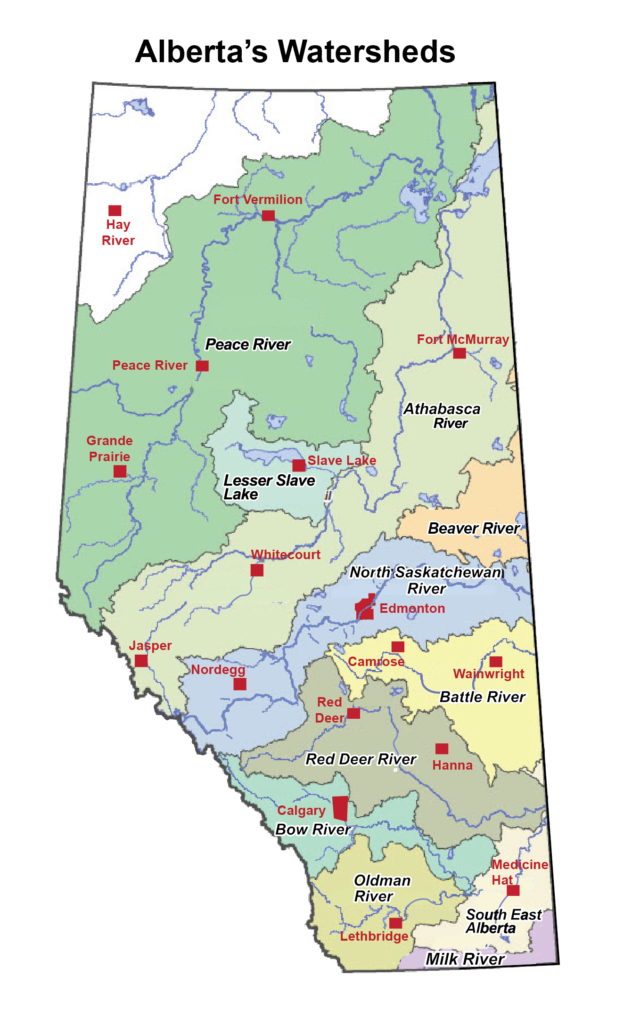
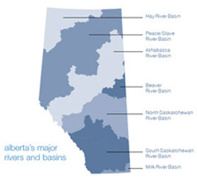
2. Watersheds in Alberta
3. Alberta’s Watersheds
Alberta Water Portal – Click here to access maps, resources and facts on Alberta’s water supply.
Battle River Watershed
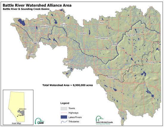
The Battle River Watershed is a large area of land covering most of east-central Alberta.
A watershed is an area of land where all water drains into a common body of water, such as a wetland, river or lake. They come in all shapes and sizes and can cross national and international borders.
The Battle River Watershed is a large area of land covering most of east-central Alberta that drains into the Battle River. The Battle River itself is a modest prairie-fed (as opposed to glacier-fed) river. There is increasing pressure on the Battle River’s water supply. The Battle Watershed covers approximately 30,000 square kilometres (17,667 square miles). 83% of this area is within Alberta; the remainder is in Saskatchewan.
Visit www.battleriverwatershed.ca for more great information.
The information, facts, maps and images on this page were provided by the Battle River Watershed Alliance and 2007-2009 Program Coordinator, Maurice Samm.
Red Deer River Watershed
Bow River Watershed
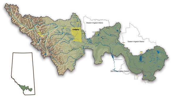
 Bow River Basin Video – HD- Water is the lifeblood of southern Alberta and the Bow River is critical to the health of the Region. This educational series of vignettes, shot in spectacular High Definition, takes the viewer on a journey of Water Stewardship of the Bow River and how that stewardship affects life in the Bow Basin.
Designed for both students and general audiences, the series looks at the importance of irrigation to life in Southern Alberta. In fact, irrigation feeds 40% of the world’s population, and not insignificantly in the Bow Basin. Not many of us know the rich history of irrigation in Alberta and how appropriate stewardship of the finite resources of the Bow River continue to benefit all of us — both urban and rural residents.
From food production to ecological protection to recreational opportunities, the series paints a fascinating and not-well-understood story of the real Bow River — not only it’s beauty, but its enduring qualities to sustain life, and of the people whose job it is to keep it that way.
The Bow River Basin is home to more than one million Albertans and welcomes hundreds of thousands of visitors every year. Valued for its beauty, and as a home for diverse fish, wildlife and plant communities, it is under immense pressure from a growing urban community and various land use impacts. This report, written for the Bow River Basin Council (BRBC) and its stakeholders, addresses the challenges faced by those whose task it is to ensure the responsible use and conservation of water resources in the basin. It updates and expands on the 1994 BRBC State of the River report.
Most of the Bow River Basin is highly altered from its natural state. Hydroelectric generation, effluent dilution, and water allocation for irrigation, municipal, industrial, agricultural, and recreational uses impact the natural flows of the river. By the time the river reaches its confluence with the Oldman River, 68% of its average annual flow has been allocated, although actual consumption is currently lower. Of the allocated water, 76% is licensed for irrigation. Population growth has placed additional demands on the water supply in the last decade and will likely become a greater challenge in the future. Climate change and glacial retreat add uncertainty to the quantity of flows for the future. Any new allocations will have a significant risk of not receiving water in drier years.
Human activities within the basin also influence water quality and the ecosystem. The impacts of stormwater runoff and wastewater effluent are particular challenges. As this report shows, water quality declines along the length of the Bow River, with higher concentrations of nutrients and pesticides in the lower reaches. Fish and riparian habitat are negatively impacted by the fluctuations in stream flows and reservoir water levels that result from hydroelectric facilities. Several dams and weirs are barriers to fish movement along the river. Lower spring and summer flows have also resulted in poor regeneration of cottonwood trees, which may disappear from the lower reaches in the next 100 to 150 years. Habitat degradation, heavy angling pressure and introduced fish species have reduced the distribution and number of some native fish species. Invasive plants have become established and wetlands have been destroyed to allow for development or agricultural production.
But the picture is not all negative; there are many positive activities ongoing within the basin. The BRBC and other organizations, government agencies and individual citizens have been addressing these issues for the past 13 years with a fair degree of success. Recent actions have led to great improvements in wastewater treatment by the City of Calgary and several smaller communities, the restoration of wetlands by organizations such as Ducks Unlimited and the Eastern Irrigation District, and water conservation programs by many municipalities and the Irrigation Districts. Many new stewardship groups and initiatives have been formed as a result of greater awareness of the issues, including Water for Life: Alberta’s Strategy for Sustainability. Volunteer groups and individuals have initiated assessment, renewal and protection programs.
Recommendations for the future focus on six themes:
1. Development of the Bow River Integrated Watershed Management Plan
2. Appropriate use and sharing of technology
3. Preparation of a Water Balance Sheet
4. Continued research and monitoring
5. Public consultation and engagement
6. Proactive contingency planning
Through implementation of these recommendations, current management practices may be improved to mitigate or avoid further pressure on the basin’s resources. We now recognize and have an understanding of the many issues and challenges facing the Bow River Basin. It is now time for all of us to take action and address them.
Ghost River Watershed
The Ghost Watershed covers almost 1,000 square kilometers and most of it is on public land in the Rocky Mountain Forest Reserve, within the MD of Bighorn. The Ghost River is a tributary of the Bow River, and it flows into the Bow just above Ghost Dam at Highway 1A about 20 km west of Cochrane.
Three smaller rivers, originating in the high ranges along the boundary of Banff National Park, form the ‘Ghost’: Waiparous Creek, North Ghost and South Ghost River. Most of the flow of the Ghost comes from the high mountains and meadows; snowmelt keeps the river flows high well into the summer, and groundwater springs feed the Ghost in the winter.
The flow rates of the rivers in the Ghost Watershed are measured at two gauge stations: one for the Ghost River and one for the Waiparous Creek. The Ghost Watershed is partially protected as the Ghost Wilderness (the upper North Ghost) and parts of the Don Getty Provincial Wildland covering the upper South Ghost and the lower North Ghost. The rest of the area, however, is unprotected.
There are only a few small settlements, some ranches and acreages in the area. The main uses of, and activities in, the Ghost Watershed are:
– Environmental services, especially water supply
– Summer grazing leases for cattle
– Forestry, mainly through clear-cut logging
– Oil and gas exploration and production
– Recreation such as horseback riding, hunting, hiking and trekking, rock and ice climbing, mountain biking, and motorized OHV recreation using trail bikes, ATVs and off-road 4×4 vehicles.
Click here for more information!
Milk River Watershed
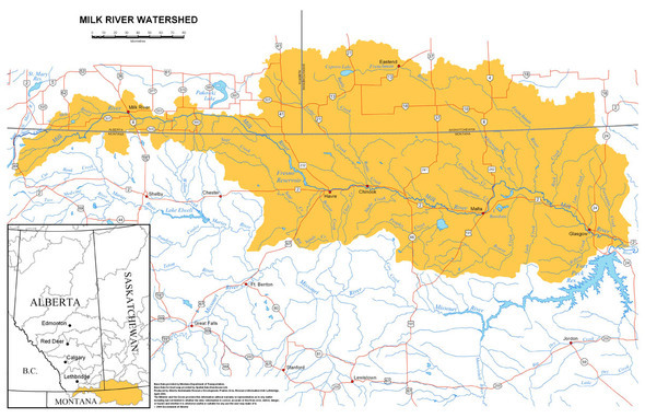
The Milk River watershed is a unique area located in the most southern part of Alberta. This watershed is known for its dry climate, extraordinary landscapes and diverse plant and wildlife communities. It is the smallest of Alberta’s seven major river basins, spanning an area of only 6,664 km2.
The Milk River originates in northwestern Montana on the Blackfoot Reservation and is the only watershed in Alberta that drains south to the Gulf of Mexico via the Missouri and Mississippi Rivers. Alberta shares this transboundary watershed with the province of Saskatchewan and the State of Montana, U.S.A. The river is about 1,173 kilometers long, and flows for a distance of about 180 km through the Town of Milk River eastward prior to looping back into Montana. The eastern tributaries (i.e., Battle, Middle and Lodge creeks) originate in the eastern part of the watershed and flow through Saskatchewan, then south into Montana before emptying into the Milk River just east of Chinook, Montana.
Total population in the watershed is approximately 2,400 people. About 50% of the population lives in the urban communities of the Town of Milk River (population of about 850) and the Village of Coutts (population of about 300). Four rural municipalities are also represented in the watershed (i.e., Cardston County, County of Warner, County of Forty Mile and Cypress County). Agriculture employs most of the labor force in the watershed (59%) while most other employment supports agriculture through retail, transportation, health, education, utilities and social services. Several brokers and insurance agents that facilitate trade and traffic to and from the United States are located in the Village of Coutts. There is oil and gas activity in the watershed with approximately eight companies operating within the watershed’s boundaries.
The Milk River watershed supports about 80% of Alberta’s species at risk and contributes to the provincial population of mule deer, pronghorn and elk. Nationally, the Milk River watershed is the most important landscape in Canada for prairie species at risk. Internationally, the watershed is a key part of the range of many migratory birds, provides key habitat for pronghorn and sage grouse and is a source area for the recolonization of swift fox in Alberta, Saskatchewan and Montana.
Although the Milk River receives substantial volumes of water from the St. Mary River diversion throughout the irrigation season, water shortages are not uncommon. The sharing of Milk River water (and St. Mary River water) is provided for in the Boundary Waters Treaty (1909) and the 1921 Order that outlines the rules of apportionment as described by the International Joint Commission. Discussions on water management across international borders continue today as resource managers strive for water sharing agreements that benefit all.
As the problem of water scarcity continues to grow and fragmentation of the landscape increases, proper water and watershed management planning is critical. To learn more about this truly unique area of Alberta, please visit the Milk River Watershed Council Website http://www.mrwcc.ca/ and refer to the State of the Watershed Report found there.
Oldman River Watershed
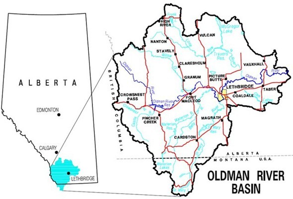
The Oldman River Watershed, located in southwestern Alberta, extends north to High River, east to Grassy Lake, west to the Crowsnest Pass in the Rocky Mountains, and dips south across the 49th parallel into Glacier International Peace Park in Montana.
The main tributaries of the Oldman River are the Livingston, Crowsnest, Castle, Waterton, Belly and St. Mary Rivers, in turn supplied upstream by numerous small streams, springs and wetlands. The Oldman River joins the South Saskatchewan River upstream from Medicine Hat. Since water flows downhill, our water – and everything we do that affects its quality – ultimately finds its way across western Canada and the Arctic Ocean.
As residents of the Oldman River Basin Watershed, we are responsible for the health of our watershed and the quality of our water.
Our basin is home to 161,400 rural and urban residents. There are about 70 small towns, villages and hamlets in the Basin, as well as the City of Lethbridge with a population near 73,000. The Watershed encompasses 28,000 km2 and has an average population density of just less than six people/km2.
Basin residents enjoy a wide variety of beautiful and productive landscapes. The headwaters of the Oldman River rise in the west among the Montane foothills of fir and pine forests, which support several historical ranches and provide critical habitat for wildlife. The central and eastern portions of the Watershed consist of dryer Fescue Grasslands and Mixed Grass areas, where some native prairie vegetation remains.
Due to the changing landscape, there are many different types of land use within the watershed. About 33% of the Watershed’s land cover is agricultural, 29% is forested and 17% is native vegetation. Recreation, concentrations of urban and industrial development, dry land farming, and intensive livestock agriculture all directly impact the health of the Oldman Watershed.
Source: Alberta Environment 2000
For more information on the Oldman River and the key issues in the watershed visit oldmanwatershed.ca/about-the-watershed/
South Saskatchewan River Watershed
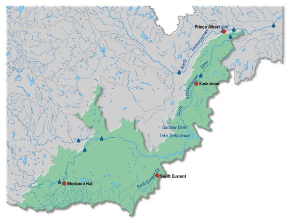
The South Saskatchewan River basin, originates in mixed grasslands at the confluence of the Bow and Oldman rivers. The sub-basin comprises the river reach of the South Saskatchewan River and its associated drainage area. The South Saskatchewan River flows east to Medicine Hat then turns northeast to the Saskatchewan boundary.
The river receives some tributary flow from small streams rising on the slopes of the Cypress Hills. Shortly after crossing the interprovincial boundary, it is joined by the Red Deer River.
Flowing east, the river enters Lake Diefenbaker – a 225 km-long reservoir created by the Gardiner Dam and the Qu’Appelle Dam. This large reservoir has a surface area of 430 km2 and a shoreline length of 800 km. The river flows northeast from the reservoir through moist mixed grasslands to Saskatoon. It continues through aspen parkland and the boreal plain to its confluence with the North Saskatchewan River.
The sub-basin has a population of about 300 000, with major centres being Medicine Hat, Swift Current and Saskatoon. Canadian Forces Base Suffield – a 2690 km2 block of unplowed grassland – is on the west bank of the river in Alberta; some of the base extends into the Red Deer River sub-basin. There are four First Nations reserves downstream of Lake Diefenbaker.
Economic activity includes a broad mix of agricultural activities, with both irrigated and dryland crop production, and livestock. Near Saskatoon, there are several dairy operations, while the upper half of the sub-basin features oil and gas production. There are seven potash mines that depend on the sub-basin’s water supply, although one is not in the sub-basin.
For more details on the South Saskatchewan River Basin – please read Chapter 9 from the State of the Saskatchewan River Basin Report.
http://www.saskriverbasin.ca/page.php?page_id=70
Fast Facts
Did you Know…
• Over 70% of the earth is covered in water, but only 3% of the earth’s water is fresh water and only 0.3% of this is useable to humans.
• The average person needs 30 to 50 litres of fresh water a day for drinking, cooking, washing and sanitation. However, the average Canadian uses more than 300 litres of water a day! Compare this to the average African, who makes do with just 10 litres a day.
• Albertans consume about 45,000 cubic decametres of water from the Battle River every year.
• Legally, Alberta must ensure that 50% of the Battle River’s water reaches Saskatchewan
• In drought years, there is not enough water in the Battle River to meet the needs of water users.
• Riparian areas are important to the health of a watershed. Water in a stream that does not have riparian vegetation will flow fast, which causes soil erosion from stream banks. A healthy river with lots of plants will curve and bend across the land and there will be less erosion.
• Alberta has 2.2% of Canada’s fresh water
About…Water & Developing Countries
Source: Centre for Affordable Water and Sanitation Technology (CAWST). Access on October 9, 2009.
• 1.1 billion people in the world do not have access to safe water, roughly one-fifth of the world’s population.
• 2.6 billion people in the world do not have access to adequate sanitation, about two-fifths of the world’s population.
• 1.8 million children and 400,000 adults, die every year from diseases associated with lack of access to safe drinking water, inadequate sanitation and poor hygiene.
• Some 4,900 people die every day from diseases associated with lack of access to safe drinking water, inadequate sanitation and poor hygiene – equivalent to 20 jumbo jets crashing every day.
• At any one time it is estimated that half of the world’s hospital beds are occupied by patients suffering from water-borne diseases.
• The average distance that women in Africa and Asia walk to collect water is 6 km.
• At any time, 1.5 billion people suffer from parasitic worm infections stemming from human excreta and solid wastes in the environment. Intestinal worms can be controlled through better sanitation, hygiene and water. These parasites can lead to malnutrition, anemia and retarded growth, depending upon the severity of the infection.
• One flush of your toilet uses as much water as the average person in the developing world uses for a whole day’s washing, cleaning, cooking and drinking.
• Comparative costs: In Europe $11 billion is spent each year on ice cream; in USA and Europe, $17 billion is spent on pet food; in Europe $105 billion is spent annually on alcoholic drinks, ten times the amount required to ensure water, sanitation and hygiene for all.
Note: Caring for our Watersheds does not take any responsibility for the information on any linked web sites. These external sources are outside of our control and it is the responsibility of users to make their own decision about the accuracy, currency, reliability and correctness of information found. The Caring for our Watersheds program does not necessarily endorse any company or organization linked to from this site.
