Watershed Resources
CARING FOR OUR WATERSHEDS is open to students who live in the Saskatchewan borders
Watershed Introductory Videos
 What is a Watershed?
A shed that holds water? Nope. Everyone in the world lives in a watershed. Watch this short video to learn what a watershed really is.
 Why Should You Care About Our Watersheds?
Protecting our watersheds is more important than ever. Fresh water and healthy soils are limited and as our world population grows we all need to do more to preserve and improve the land, air and water.
 Nutrien Watershed Contest
Youth around the world are turning their environmental ideas into solutions. The Caring for Our Watersheds program asks the question, “What can you do to improve your watershed?” Answer the question and take action in your community!
Water Nexus Videos
This video series is generously provided by Alberta WaterPortal Society.
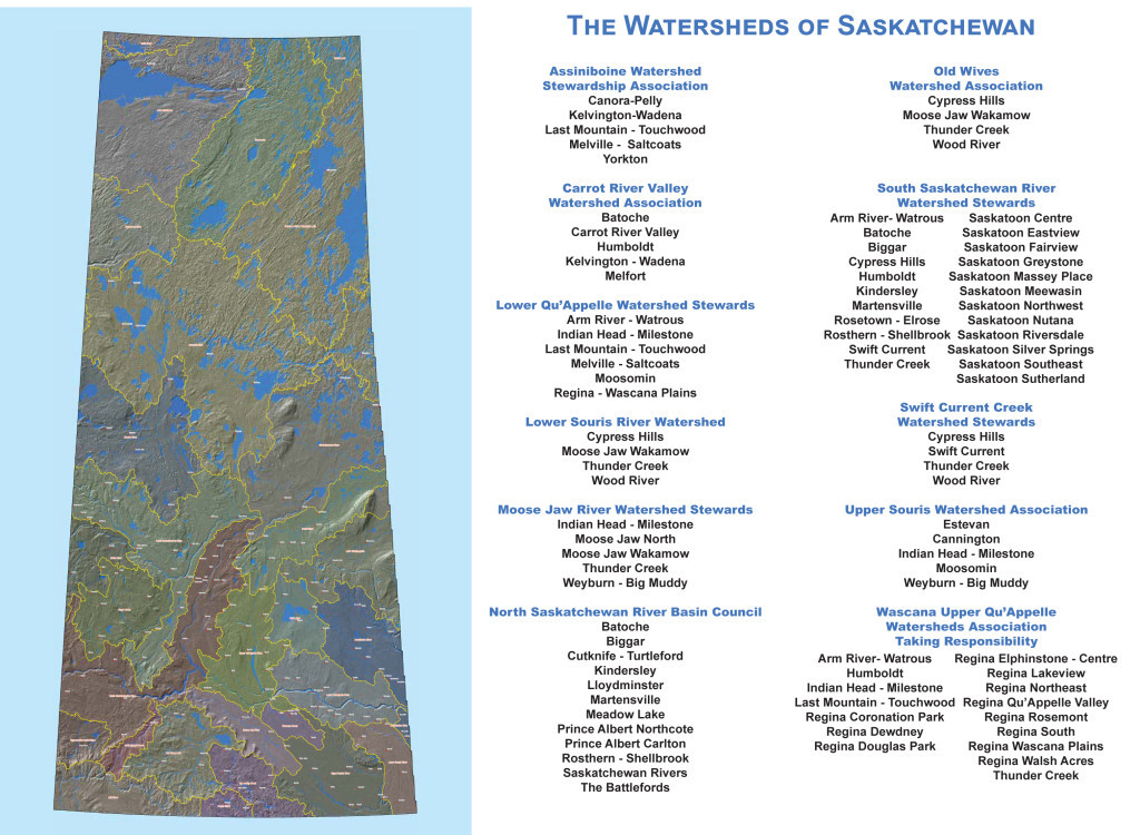
Saskatchewan Watersheds
- Assinboine Watershed Stewardship Association
- Carrot River Valley Watershed Association
- Lower Qu’Appelle Watershed Stewards
- Lower Souris River Watershed
- Moose Jaw River Watershed Stewards
- North Saskatchewan River Basin Council
- Old Wives Watershed Association
- South Saskatchewan River Watershed Stewards
- Swift Current Creek Watershed Stewards
- Upper Souris Watershed Association
- Wascana Upper Qu’Appelle Watershed Association
South Saskatchewan River
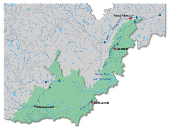
The South Saskatchewan River basin, originates in mixed grasslands at the confluence of the Bow and Oldman rivers. The sub-basin comprises the river reach of the South Saskatchewan River and its associated drainage area. The South Saskatchewan River flows east to Medicine Hat then turns northeast to the Saskatchewan boundary.
The river receives some tributary flow from small streams rising on the slopes of the Cypress Hills. Shortly after crossing the interprovincial boundary, it is joined by the Red Deer River.
Flowing east, the river enters Lake Diefenbaker, a 225 km-long reservoir created by the Gardiner Dam and the Qu’Appelle Dam. This large reservoir has a surface area of 430 km2 and a shoreline length of 800 km. The river flows northeast from the reservoir through moist mixed grasslands to Saskatoon. It continues through aspen parkland and the boreal plain to its confluence with the North Saskatchewan River.
The sub-basin has a population of about 300 000, with major centres being Medicine Hat, Swift Current and Saskatoon. Canadian Forces Base Suffield, a 2690 km2 block of unplowed grassland, is on the west bank of the river in Alberta; some of the base extends into the Red Deer River sub-basin. There are four First Nations reserves downstream of Lake Diefenbaker.
Economic activity includes a broad mix of agricultural activities, with both irrigated and dryland crop production, and livestock. Near Saskatoon, there are several dairy operations, while the upper half of the sub-basin features oil and gas production. There are seven potash mines that depend on the sub-basin’s water supply, although one is not in the sub-basin.
For more details on the South Saskatchewan River Basin, please read Chapter 9 from the State of the Saskatchewan River Basin Report.
Resources
Assiniboine Watershed Stewardship Association
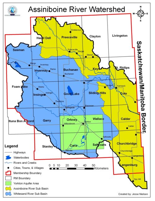
The Assiniboine Watershed Stewardship Association (AWSA) is an independent, non-profit organization that is dedicated to protecting and enhancing source water in the Assiniboine River Watershed.
In October 1996, the governments of Saskatchewan (Sask Water), Manitoba (Manitoba Conservation) and Canada (Environment Canada) agreed to conduct the Upper Assiniboine River Basin Study. The study was initiated as a result of the 1995 flood and other issues, including drainage municipal, industrial, agricultural and recreational purposes and a lack of knowledge regarding the hydrologic and ecological processes and their appropriate measures for aquifer management and protection. The Upper River Basin Study provided information regarding the Basin’s water resources, and information and recommendations on which to base decisions affecting future water management. The study was organized into the Upper Assiniboine River Basin Study in August, 2000.
Following their establishment in October, 2002, the Saskatchewan Watershed Authority began a watershed management and aquifer planning initiative across the province. in 2004, two Watershed Advisory Committees were established within the Assinboine River Watershed to lead the planning and decision-making process, the Assinboine River Advisory Committee and the Yorkton Area Aquifers Advisory Committee. The two committees were made up of local representatives from Rural and Urban Municipalities, First nations, as well as stewardship, agricultural and other interest groups.
With the creation of the two source water protection plans, an organization needed to be established to implement the plan’s key actions. This brought about the formation of the Assiniboine Watershed Stewardship Association Inc, which was incorporated as a non-profit organization on January 23, 2007, with their office opening in May of 2007. The AWSA is unique amongst watershed groups in the province in that it implements two source water protection plans, owing to the critical importance of groundwater in the Assiniboine River Watershed.
We work closely with all levels of government, as well as other stewardship groups and private agencies, to complete the key actions contained in our two Source Water protection Plans. The Assiniboine River Watershed is an exceptional area with its own unique source water concerns. The Source Water Protection Plans target the highest ranking risks that are threatening the water supplies. The AWSA provides local solutions to local problems, while also providing a place people can call for help with their own water-related issues. Through the actions of the association, we strive to ensure that every person in the Assinboine River Watershed has a safe, reliable supply of drinking water, now and into the future.
Carrot River Valley Watershed Association (CRVWA)
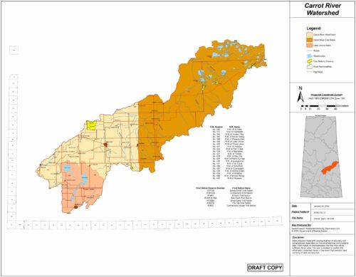
Part of the Saskatchewan River Basin, the Carrot River Watershed is located in both Saskatchewan and Manitoba, and covers an area of approximately 17,500 square kilometers. Nearly 15,750 square kilometers of this watershed are in Saskatchewan. This portion of the Carrot River Watershed includes the City of Melfort, seven towns, eleven villages, twenty one Rural Municipalities and six First Nation Reserves contributing to the estimated population of 25,500 people. Approximately 13,500 of this total population are rural residents and the remaining 12,000 reside in urban centres. The majority of the population is concentrated in the south central area of the watershed.
The Carrot River is the dominant watercourse in this watershed, and its headwaters originate in the Cudworth and Tiger Hills Plains near the Town of Wakaw. The outlet of Wakaw Lake marks the start of the Carrot River, and from there the river flows northeast through Melfort and Red Earth Plains until it reaches the Saskatchewan River west of The Pas, Manitoba. The Carrot River is approximately 300km long, and its course runs parallel to the South Saskatchewan and Saskatchewan Rivers. In fact, the distance between these rivers never exceeds 50km while the width of the Carrot River Watershed never exceeds 80km. The Lenore Lake internal drainage basin is within the Carrot River Watershed, and the unique topography of this basin has developed several saline waterbodies. In fact, all of lakes within the Lenore Lake Basin are saline with the exception of St. Brieux and Burton Lakes.
Dedicated to preserving the character and integrity of the Carrot River Watershed through education and awareness, the Carrot River Valley Watershed Association (CRVWA) is a non-profit, non-governmental organization that incorporated in 2011. Serving the Saskatchewan portion of the Carrot River Watershed, the CRVWA works to give community members the informed insight and tools they need to make positive changes in the watershed by working together to protect source water and the natural beauty of our watershed for current and future generations. The goal of the CRVWA is to protect and improve water quantity, water quality, and diversity of the watershed through collaborative planning and facilitating partnerships.
Information provided by the Carrot Valley Watershed Association
North Saskatchewan River Basin Council
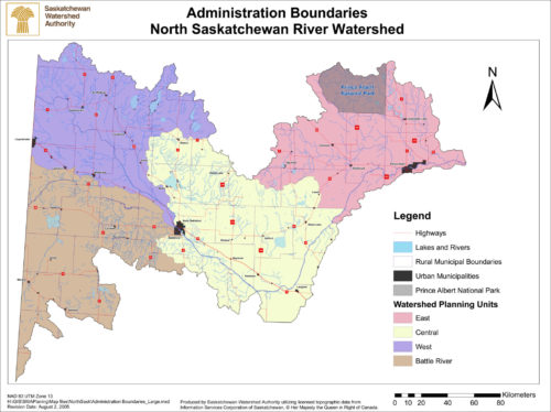
The North Saskatchewan River Basin Council (NSRBC) is a non-profit organization that has formed to support and direct the implementation of the Source Water Protection Plan (SWPP) for our watershed. The plan has been built over 4 years of public consultations with the assistance of the Water Security Agency.
Water knows no boundaries. It flows over the surface, underground through farms, cities and across jurisdictions. We are all linked by its path and our need for it. Understanding how we affect the water near us and how that affects the water further downstream is the first step in realizing the importance of protecting what we all share and need.
Many of the activities occurring within the watershed impact water quality. There are steps we can take to ensure our activities do not have negative impacts on our water sources. Then we are not only protecting water for ourselves and each other, but for future generations.
Our vision is a watershed which provides for the social, economic, environmental and cultural water needs of future generations.
Because the watershed is so large and source water protection is a long term project we need community support in order to be successful. Water affects everyone so it is important that everyone has a chance to be involved with protecting it.
Watershed education is a key component of our organizations activities. It is our belief that action is born through awareness that is fostered through education. In the past we have delivered various school programs across the watershed to promote watershed awareness and education and to empower the youth to take local action.
Information provided by The North Saskatchewan River Basin Council.
Swift Current Creek Watershed Stewards
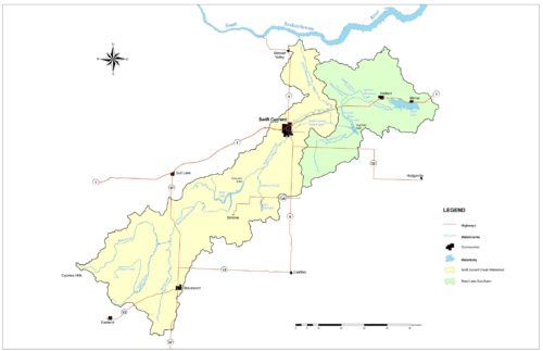
The Swift Current Creek Watershed Stewards (SCCWS) is a non-profit organization that promotes ecological sustainability in our community. Our mandate is to enhance water quality and stream health of the Swift Current Creek Watershed by promoting awareness and understanding among water users.
The organization, formed in 2011, of watershed residents who partner with government representatives to locally design and deliver programs and initiatives that follow an ecosystem and watershed approach to cooperative planning and management of our resources.
Ultimately, we are building the capacity for our community to achieve a stewardship ethic for the long-term. This is accomplished by educating watershed users, monitoring water quality and riparian health, and fostering an attitude of individual responsibility towards stewardship.
Our membership spans local farmers, rural residents, the City of Swift Current, surrounding Rural Municipalities and various governmental organizations.
The SCCWS have successfully implemented numerous creek monitoring projects and have implemented beneficial management projects in areas where the monitoring showed there was an issue with the health of the creek. These projects have been implemented in both rural and urban settings.
Water quantity is an issue in south western Saskatchewan as such the SCCWS encourage stakeholders to conserve and reuse water resources whenever possible through such programs as the Rain Barrel Workshops held throughout the watershed yearly.
Information provided by the Swift Current Creek Watershed Stewards
Wascana Upper Qu’Appelle Watershed Association
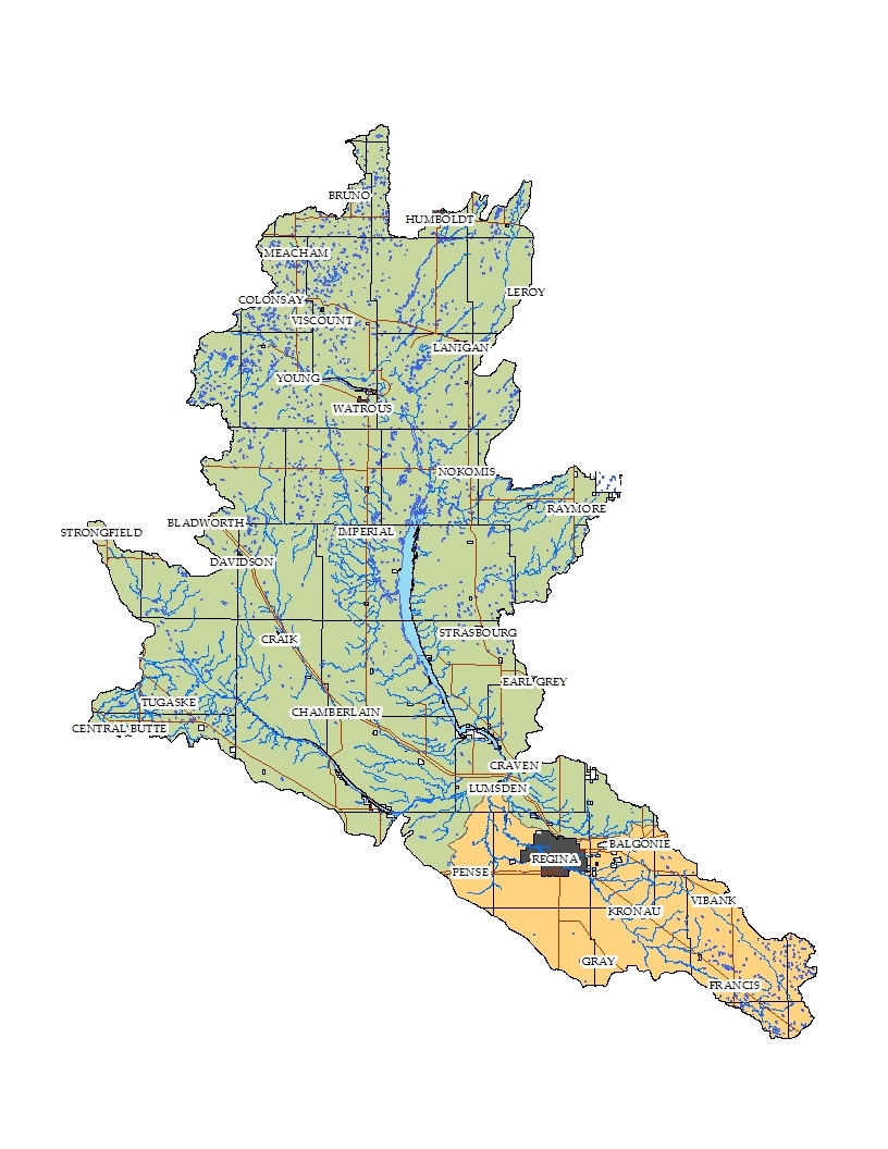
Within the boundaries of the Wascana Creek and Upper Qu’Appelle River Watersheds there are 35 rural municipalities (partial and whole), 69 urban municipalities (cities, towns, villages and resort villages) and 17 hamlets/organized hamlets. The population of the urban municipalities is 221,209 people and 20,121 in the Rural Municipalities (2011 census data). The total number of people in the watershed area is 241,330. The Upper Qu’Appelle River Watershed has subwatersheds; the Lanigan-Manitou, the Last Mountain Lake and the Upper Qu’Appelle (sometimes referred to as the Buffalo Pound subwatershed). The Moose Jaw River Watershed is also drains into the Upper Qu’Appelle watershed but is considered its own watershed area. The Upper Qu’Appelle watershed (not including the Moose Jaw River watershed) is about 14,143 square km.
More information can be found on www.wuqwatr.ca
Wascana Watershed
The Wascana Watershed is one of the smallest in Saskatchewan with a land area of 3870 square km, or about 1% of Saskatchewan’s total area, but contains over 20% of the province’s population. Because it contains the City of Regina, it has the largest population density of any Saskatchewan watershed. That means our impacts are even greater than in other areas.
Water features in the Wascana Watershed include Wascana Creek and Wascana Lake, Cottonwood Creek and Manybones Creek.
Wascana Creek begins near Davin, southeast of Regina and flows southeast, then loops around to the west, through Wascana Lake in the City of Regina and then enters the Qu’Appelle River outside of Lumsden. Wascana Creek wanders through its course. As the crow flies it is 185 km long, but it travels a distance of 272 km.
The Creek’s elevation drops 215 m from 695 m above sea level at its headwaters to 480 m above sea level at its outlet in the Qu’Appelle Valley.
Upper Qu’Appelle Sub-Watershed
In the Upper Qu’Appelle River watershed the main water course is the Qu’Appelle River. It is fed by several rivers/creeks which include Ridge Creek, Iskwao Creek, High Hill Creek, Deer Run Creek, Wascana Creek, Boggy and Flying Creeks, Last Mountain Creek and Moose Jaw Creek. Ridge Creek runs near Central Butte. Deer Run Creek runs west of Davidson. Flying Creek runs south of Craven and east of Lumsden while High Hill Creek flows west of Lumsden. There are two major lakes in the Upper Qu’Appelle River watershed: Buffalo Pound Lake and Eyebrow Lake. Buffalo Pound Lake serves as the water supply for 25% of Saskatchewan’s population, including the Cities of Regina and Moose Jaw, as well as major industrial and recreational users. Eyebrow Lake is upstream of Buffalo Pound Lake. It is part of the Nisku Wildlife Management Project.
Lanigan-Manitou Sub-Watershed
In the Lanigan-Manitou subwatershed the major water courses (rivers/creeks) are Lanigan Creek, Wolverine Creek, Saline Creek and Dellwood Brook. The largest water body is Little Manitou Lake, a closed basin mineral lake that supplies water to the local mineral spa. It is known for its reputed healing properties and brine shrimp. Other lakes include Freshwater Lake east of Little Manitou Lake, Humboldt Lake southeast of Humboldt, and Wolverine Lake located west of Burr. The latter two are operated as flood control measures by the Lanigan Creek – Dellwood Brook Watershed Association as well as a source of water for recreation and irrigation. There are also two dams and reservoirs owned by the Water Security Agency: the Zelma and Dellwood reservoirs. They are fed by water from Lake Diefenbaker through the Saskatoon South East Water Supply (SSEWS) conveyance system. Both systems provide water for rural municipalities, towns and the surrounding potash mines to the east including the proposed new mine near Jansen Lake.
Last Mountain Lake Sub-Watershed
In the Last Mountain Lake subwatershed the major water courses are Lanigan Creek, Arm River, and Lewis Creek that feed Last Mountain Lake. There are also a number of ephemeral creeks and streams that contribute spring run off to Last Mountain Lake. Lanigan Creek feeds Last Mountain Lake at its north end just southeast of Simpson. The Arm River starts near Kenaston and runs roughly parallel to Last Mountain Lake on the west side and feeds into it near Regina Beach. Lewis Creek originates at Devil’s Lake, southwest of Watrous, and feeds into the lake north of Etter’s Beach. The one major reservoir is the Craik Reservoir, which serves to provide water for the municipality, irrigation and as a recreation site. The largest lake in the area is Last Mountain Lake. It is fed by the aforementioned creeks and is used in part as a control measure for flood protection for land and communities downstream. It is a well-known area for recreation, fishing and the north end hosts a wildlife preserve and national bird sanctuary.
Lifestyle Calculator:
How much land area does it take to support your lifestyle? Take this quiz to find out your Ecological Footprint, discover your biggest areas of resource consumption, and learn what you can do to tread more lightly on the earth.
Free Lesson Plans:
Wetland education plans for teachers and students provided by Ducks Unlimited Canada.
Useful Links:
- Ducks Unlimited Canada
- State of the Saskatchewan River Basin
- South Saskatchewan River Watershed Stewards (Be sure to check out the source water protection plan and the background document).
- Saskatchewan Watershed Authority Stewardship Programs
- Partners FOR the Saskatchewan River Basin
- Meewasin Valley Authority
Fast Facts
Did you Know?
- Over 70% of the earth is covered in water, but only 3% of the earth’s water is fresh water and only 0.3% of this is useable to humans.
- The average person needs 30 to 50 litres of fresh water a day for drinking, cooking, washing and sanitation. However, the average North American uses more than 300 litres of water a day! Compare this to the average African, who makes do with just 10 litres a day.
- Riparian areas are important to the health of a watershed. Water in a stream that does not have riparian vegetation will flow fast, which causes soil erosion from stream banks. A healthy river with lots of plants will curve and bend across the land and there will be less erosion.
About Water & Developing Countries
Source: Centre for Affordable Water and Sanitation Technology (CAWST). Access on October 9, 2009.
- 1.1 billion people in the world do not have access to safe water, roughly one-fifth of the world’s population.
- 2.6 billion people in the world do not have access to adequate sanitation, about two-fifths of the world’s population.
- Some 4,900 people die every day from diseases associated with lack of access to safe drinking water, inadequate sanitation and poor hygiene, equivalent to 20 jumbo jets crashing every day.
- The average distance that women in Africa and Asia walk to collect water is 6 km.
- One flush of your toilet uses as much water as the average person in the developing world uses for a whole day’s washing, cleaning, cooking and drinking.
- Comparative costs: In Europe $11 billion is spent each year on ice cream; in USA and Europe, $17 billion is spent on pet food; in Europe $105 billion is spent annually on alcoholic drinks, ten times the amount required to ensure water, sanitation and hygiene for all.
Note: Caring for our Watersheds does not take any responsibility for the information on any linked web sites. These external sources are outside of our control and it is the responsibility of users to make their own decision about the accuracy, currency, reliability and correctness of information found. The Caring for our Watersheds program does not necessarily endorse any company or organisation linked to from this site.
