Watershed Resources
CARING FOR OUR WATERSHEDS: Colorado is open to students who live in the Colorado borders within the Cache la Poudre River Watershed and Big Thompson Watershed.
Watershed Introductory Videos
 What is a Watershed?
A shed that holds water? Nope. Everyone in the world lives in a watershed. Watch this short video to learn what a watershed really is.
Why Should You Care About Our Watersheds?
Protecting our watersheds is more important than ever. Fresh water and healthy soils are limited and as our world population grows we all need to do more to preserve and improve the land, air and water.
Nutrien Watershed Contest
Youth around the world are turning their environmental ideas into solutions. The Caring for Our Watersheds program asks the question, “What can you do to improve your watershed?” Answer the question and take action in your community!
Water Nexus Videos
This video series is generously provided by Alberta WaterPortal Society.
Colorado Watersheds
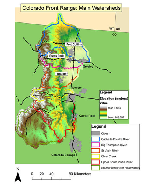
Cache la Poudre River Watershed
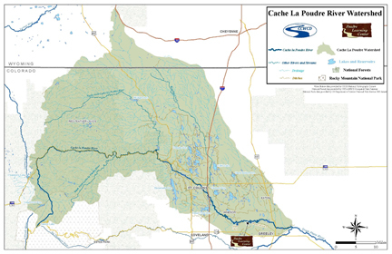
Poudre By the Numbers:
1 – Number of people it takes to make a difference. Are you this person?
140 – Distance in miles from the headwaters in Rocky Mountain National Park (RMNP) to the confluence with the South Platte River just east of Greeley.
1,915– The amount of square miles that the Poudre River drains – about the size of the state of Delaware (1,954 miles2)
6,155 – The elevation change in feet between the source of Big South Fork of the Poudre River (Poudre Lake in RMNP) and its confluence with South Platte River.
Poudre History:
1860’s – Cache la Poudre River becomes one of the first rivers tapped for irrigation in Colorado
1870 – Greeley Ditch #3 was built, taking water from the Cache la Poudre River. The Ditch was important for two reasons: It was the first decreed Ditch in USA, and secondly it created the water law, “First in time, first in right” The law means that the first people who use the water have rights over people who may live closer to the water.
1920 – Parshall Flume was developed on Jackson Ditch, an irrigation ditch diverting water from the Poudre River. The Parshall Flume is the most widespread method for measuring stream discharge.
1938-1957 – The Colorado Big Thompson Project is built. It transfers water from the west side of the continental divide to the east side. 80% of Colorado’s precipitation falls on the western slope, yet 80% of the population lives on the eastern slope (in the Front Range).
1986 – Cache la Poudre River becomes Colorado’s first National Wild and Scenic River. Thirty miles of the river are classified Wild and 45 miles are classified Recreational. No new dams or diversions will be built within these designated corridors.
1996 – The Cache la Poudre River National Heritage Area was established by an act of the US Congress in October. It was the first National Heritage Area to be established west of the Mississippi River.
2005 – The Poudre Learning Center opens, leading students to a lifetime of caring for their environment and learning more about the place they call home.
Big Thompson Watershed
- The Big Thompson River begins high in Rocky Mountain National Park at an elevation of 11,310 feet (3,447 meters) above sea level. It flows some 65 miles until it merges with the South Platte River at an elevation of 4,670 feet (1,423 meters) above sea level. That is a change in elevation of over 6,600 feet!
- Eighty percent of Colorado’s precipitation falls on the western slope of the Rocky Mountains, while approximately 80% of the states population lives on the Eastern Slope between the cities of Fort Collins and Pueblo.
- The Colorado-Big Thompson Project is a large water diversion project designed to collect West Slope mountain water from the headwaters of the Colorado River and divert it to Colorado’s Front Range and plains.
- The Big Thompson River flows into Estes Park where it is held in Lake Estes by Olympus Dam before being released into the Big Thompson Canyon. After emerging from the canyon, the big Thompson River flows through Loveland, Colorado on its way to merge with the South Platte River west of Greeley.
- The North Fork of the Big Thompson River also begins in Rocky Mountain National Park, on the northern slopes of the Mummy Range.
- The North Fork of the Big Thompson River flows east, through the town of Glen Haven where it merges with the Big Thompson River in the town of Drake.
- The Big Thompson River receives the Little Thompson River approximately 4 mi (6 km) upstream from its confluence with the South Platte River.
- The little Thompson River flows east from Roosevelt National Forest through the town of Berthoud, and between Longmont and Loveland.
- There are no man-made dams on the Little Thompson River.
- Within the Big Thompson watershed there are 173 lakes.
- The Big Thompson watershed encompasses 900 square miles!
- The Big Thompson River is a third order river.
- The Big Thompson River watershed provides drinking water to approximately 800,000 people living in Colorado’s Front Range!
- The Big Thompson River watershed provides 270,000 acre feet of water for agricultural use each year. That is 87,979,770,000 gallons of water a year!
- On July 31, 1976, during the celebration of Colorado’s centennial, the Big Thompson Canyon was the site of devastating flash floods that swept down the steep and narrow canyon, claiming the lives of 143 people, 5 of whom were never found.
- Changes in the earth result from interactions among the atmosphere (air), hydrosphere (water, including oceans, rivers and lakes), biosphere (life), and the lithosphere (rocks and soil).
- The Big Thompson River provides habitat for a multitude of aquatic and terrestrial species of plants and animals.
- The Big Thompson River is also a source of recreation for the residents of northeastern Colorado.